![]()
![]()
| ||
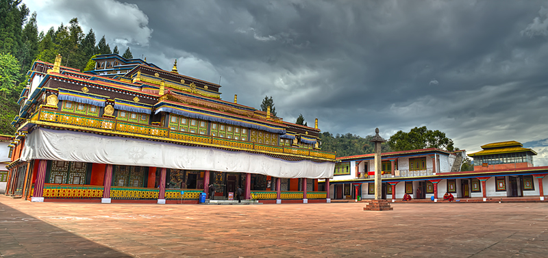
History: Gangtok became a popular Buddhist pilgrimage site after the construction of the Enchey Monastery in 1840. In 1894, the ruling Sikkimese Monarch Chogyal, Thutob Namgyal, transferred the capital to Gangtok. In the early 20th century, Gangtok became a major stopover on the trade route between Lhasa in Tibet and cities such as Kolkata (then Calcutta) in British India. After India won its independence from Britain in 1947, Sikkim chose to remain an independent monarchy, with Gangtok as its capital. In 1975, after the integration with the union of India, Gangtok was made India's twenty-second state capital. | ||
H ow to reach?
| ||
W here to stay? There are many good hotels in Gangtok such as Hotel Sonam , Norkhill Hotel ,The Anola Hotel The Oriental ,Hotel Sagorika ,Tibet Hotel ,Mintokling Guest House etc. | ||
Whato see? The places to visit in and around Gangtok are Do-Drul Chorten Stupa, Deer Park, Enchey Monastery, White Hall Permanent Flower Show, Ridge Park, Tashi View Point, Hanuman Tok, Government Institute of Cottage Industry, Sikkim Research Institute of Tibetology(SRIT), Tashi view point, Ganesh Tok, Himalayan Zoo, Sa-Ngor-Chotshog Centre. | ||
| ||
H istory:`The history of Goalpara goes back to several centuries. Based on the Chinese traveler `Hiuentsang` report, Sir Edward Gait had concluded that the erstwhile capital of the state of Kumar Bhaskar Varman was either in Goalpara District or in CoochBehar. The district came under British rule in 1765. Before this the area was under the control of the Koch dynasty. In 1826 the British accessed Assam and Goalpara was annexed to Assam in 1874. | ||
H ow to reach? Goalpara can be reached from Guwahati by train, bus or car. Guwahati can be reached by train or road. Airports connected to Guwahati (GAU) are Barapani Airport, Shillong (SHL) Domestic 168 km, Netaji Subhash Chandra Bose Intl Airport, Kolkata (CCU) International 456 km, Indira Gandhi Intl Airport, Delhi (DEL) International 1509 km | ||
W here to stay? Few good hotels are :Paramount Hotel, Siddharth Hotel, Blue Diamond Lodge, Hollywood Hotel etc. | ||
W hat to see? Goalpara is famous for scenic beauty and migratory birds.
| ||
| || India- Places of Interest || | ||
   | ||
H istory: Once known as Pragjyotishpura (the Light of the East), Guwahati derives its name from the Assamese words "Guwa" meaning areca nut and "Haat" meaning market. Guwahati is the largest city in Assam and Northeast India. It used to be the capital of Assam before it was moved to the planned city of Dispur. Guwahati's myths and history go back several thousands of years. Although the date of the city's beginning is unknown, references in the epics, puranas, and other traditional histories, lead many to assume that it is one of the ancient cities of Asia. The Ambari excavations trace habitation in the city to the sixth century C.E. It was a Mughal outpost when they occupied lower Assam, and became the seat of the Borphukan, the Ahom viceroy for the western part of the Ahom kingdom. There are a number of historical features in Guwahati. The Dighalipukhuri is a rectangular lake that was connected to the Brahmaputra, and was probably dug for naval reasons by the Ahoms. | ||
H ow to reach?
| ||
W here to stay? Several hotels, lodges and Dharmshalas are located in Guwahati. Few hotels are : Hotel Nandan, Hotel Brahmputra Ashok, Hotel Ginger Guwahati, Hotel Ambrish, Hotel Pragati, Hotel Dynasty etc. | ||
W hat to see? The city of Guwahati has on offer numerous tourist sites, some religious and some natural, for the travelers. These tourist attractions in Guwahati see the footfalls of several tourists from far and wide all the year round.
| ||
| ||
H istory: Gulmarg has been a resort for the kings like Yousuf Shah Chak and Jahangir who used to visit frequently. The old name of Gulmarg was "Gaurimarg", the name of Lord Shiva's wife. Yousuf Shah Chak changed its name to Gulmarg, meaning the place of roses. During the early part of the 20th century the famous Central Asian explorer Sir Marc Aurel Stein (1862 – 1943), made his home here in a tent between his expeditions. It was a favorite summer holiday destination for the British stationed in India. | ||
H ow to reach? Gulmarg can be accessed from Srinagar (the capital of Kashmir) in about 1 hour by car or bus. The buses will reach Tangmarg in about 45 minutes. From Tangmarg, for the 13 km hill road, jeeps can be hired for reaching Gulmarg hilltop in about 30 minutes. The last jeep down from Gulmarg is available at sunset. | ||
W here to stay? Gulmarg has around 40 hotels of all grades. The peak season starts with the snow fall in December and lasts until June. | ||
W hat to see? It is a famous ski destination. Gulmarg boasts Asia's highest cable car project, the Gulmarg Gondola. The two-stage ropeway ferries about 600 people per hour to and from Kongdoori Mountain, a shoulder of nearby Afarwat Peak (4,200 m (13,780 ft)). The ropeway project is a joint venture of the Jammu and Kashmir government and French firm Pomagalski. The first stage transfers from the Gulmarg resort at 2,600 m (8,530 ft) to Kongdoori Station in the bowl-shaped Kongdori valley. The second stage of the ropeway, which has 36 cabins and 18 towers, takes skiers to a height of 3,950 m (12,959 ft) on Kongdoori Mountain.Getting around Gulmarg is done mostly by foot. There is one road that does a loop around the whole area. Walking around it would take about an hour. You can even see around Gulmarg in sledges driven by locals. | ||
| ||
H istory: Gwalior is said to take its name due to curing of a prince by a sage. Suraj Sen, a prince of the Kachhwaha clan of the eighth century, is said to have lost his way in the jungle. On a secluded hill he met an old man, the sage Gwalipa, whose influence almost took him by surprise. Upon asking the sage for some drinking water he was led to a pond; the waters not only quenched his thirst but cured him of leprosy. Out of gratefulness, the prince wished to offer the sage something in return, and the sage asked him to build a wall on the hill in order to protect the other sages from wild animals which often disturbed their yagnas (or pujas). Suraj Sen later built a palace inside the fort, which had been named "Gwalior" after the sage; eventually the city which grew around the fort took the same name. | ||
H ow to reach?
| ||
W here to stay? In addition to these, there are also numerous budget and economical hotels in Gwalior. These hotels are ideal for travelers who wish to have pleasant and comfortable accommodation in the city without spending huge sums of money. Few hotels are :
| ||
W hat to see?
| ||
| GOPALPUR OR SEA, ORISSA | ||
H istory: Gopalpur was an ancient, commercial port, now lying in ruins. From an obscure little fishing village, Gopalpur became a prominent trading port during the days of British East India Company. The East India Company built large warehouses and because the trade with Burma had picked up and it had become a trading point for rice from Rangoon. The British and the wealthy Bengalis, who once made Gopalpur a vibrant, happening place, have left. Gopalpur has reverted to being a quiet, relaxed place but with one major difference — it is one of India's most sought after beaches, with a distinct charm of its own. | ||
H ow to reach?
| ||
W here to stay? Good accommodation options like seaside resorts, luxurious hotels, and old bungalows are available. Price depends on the season and demand. Services are good and rooms at most of the places give excellent view of the sea. | ||
W hat to see? Chilka Lake is situated at a distance of 45 km from Gopalpur. Spreading over an area of 1100 sq km, this is the largest brackish water lake in the country and attracts large number of migratory birds. Taptapani (hot water), as the name suggests, is a hot water sulfur spring situated around 67 km from Gopalpur. Gopalpur on sea is a miniature seaside haven where boating, yachting, and a seaside run invite visitors to share the expanse and have fun. | ||
| ||
| H istory: Hyderabad is presently capital of Sate of Telangana. Thr city was founded in the year 1591 by Mohammed Quli Qutub Shah, the fifth sultan of Qutb Shahi dynasty. Presently it is one of the fastest growing cities of India and has emerged as a strong industrial, commercial, technology center. Establishment of the Qutb Shahi dynasty : Quli Qutb Shah seized the reins of power from the Bahamani kingdom in 1512 and established the fortress city of Golconda. Inadequacy of water, and frequent epidemics of plague and cholera persuaded Mohammed Quli Qutub Shah to venture outward to establish new city with the Charminar at its centre and with four great roads fanning out four cardinal directions. Hyderabad's fame, strategic location and Golconda's legendary wealth attracted Aurangazeb who captured Golconda after a long seize in 1687. After this defeat the importance of Hyderabad declined and the city fell into partial ruins. As the Moghul empire decayed and began to disintegrate, the viceroy, Asaf Jah I proclaimed himself the Nizam and established independence rule of the Deccan. Hyderabad once again became a major capital city, ruled by successive Nizams of the Asaf Jahi dynasty until the state was merged into Indian Union in 1948. | ||
H ow to reach? Hydearabad is well connected to other cities of India by air, train and road. It has a world class new International air port as`well. | ||
W here to stay? There are many expensive and budget hotels in Hyderabad. Few hotels are Hotel Taj Krishna, Taj Deccan, Novotel, Hotel Vice Roy, Hotel Kshatriya, Hotel city Park etc. | ||
W hat to see?
| ||
| ||
H istory: Hampi is a village in northern Karnataka state, India. It is located within the ruins of Vijayanagara, the former capital of the powerful Vijayanagara Empire. Predating the city of Vijayanagara, it continues to be an important religious centre, housing the Virupaksha Temple, as well as several other monuments belonging to the old city. As the village is at the original centre of Vijayanagara, it is sometimes confused with the ruined city itself. The ruins are a UNESCO World Heritage Site, listed as the Group of Monuments at Hampi. Hampi is identified with the historical Kishkindha, the Vanara (monkey) kingdom mentioned in the Ramayana. The first historical settlements in Hampi date back to 1 CE. Hampi formed one of the cores of the capital of the Vijayanagara Empire from 1336 to 1565, when it was finally laid siege to by the Deccan Muslim confederacy. Hampi was chosen because of its strategic location, bounded by the torrential Tungabhadra river on one side and surrounded by defensible hills on the other three sides. The site is significant historically and architecturally. | ||
H ow to reach?
| ||
W here to stay? One has to stay at Hospet or Bellary. Some hotels are Hotel Malligi, JN Road, Off Hampi Road, Hospet, Hotel Priyadarshani, Station Road, Hospet. Shanbhag Towers International, Marchad Residency, Bellary, Ashoka Comforts, Bellary, KSTDC Mayura Vijayanagar, Hampi, Bala Regency Hotel, Bellary, Shyamala Hotel Location: Bellary, Amruth Lodge Location: Bellary, Royal Tourist Home, college Road Hospet. | ||
W hat to see? Hampi was the capital of Vijayanagar(14th century empire). The ruins of the empire is spread over the area of 26 sq km. It seems at one point of time, diamonds were sold on the streets of this empire. Hampi is well worth the visit. The area is simply stunning and you will be in awe of the millions of boulders surrounding the area. However, within this arid landscape lies a little oasis with lush palm, banana, and mango trees nestled near the river. Hampi is a great place to spend a few days wandering around and discovering the rich, vibrant history while also having a bit of 'your' time. Hampi hosts 'Hampi Utsav' every year during first week of November. Hampi is a visual delight, especially due to its stark contrast from most other places. Rocks are all you see whichever direction you look at. Vegetation is visible in the wet months; but again it never dominates the landscape. It is an ideal spot for people who are interested in history and/or nature. There are many sites of interest in and around Hampi. The must-visits are Virupaksha Temple, Hampi Bazaar, Monolith Bull, Lakshmi Narasimha temple, Hemakuta Hill temples, Big Shivlinga, Vithala Temple (the famous Stone Chariot is located here), Hazara Rama Temple, Royal Enclosures, Queen's Bath, Zanana Enclosure (which also houses the Lotus Mahal), Elephant Stables, Achyut Raya temple, Statue of Ugra Narsimha, Virupaksha Temple, Mahanavmi Dibba, the Stepped Bath and the Matanga Hill (from where one can see the most beautiful sun set ever). All these places are towards Hampi Bus Stand area and you dont need to cross river. Tungbhadra dam is another 16 km from Hampi and it is towards Hospet. There are also several "Shivalings" along the river which the boatman will guide you to. The old capital called Anegundi, across the river from Hampi also has many sites. The Hanuman Temple on Anjenaya Hill (involves climbing up 572 steps, is believed to be the birth place of Hanuman) and the Old Palace are definitely worth a visit. There is Doroji bear sanctuary around 16 kms from Hampi, opposite side of Kamalapura/Hospet. | ||
| ||
H istory:
| ||
H ow to reach? Hardwar is one of the most famous pilgrimage places in India and it is easily accessible from every places in India. Haridwar city of Uttarakhand is well linked by air, rail and road to Delhi and hence to all the major cities in India. Rishikesh can be accessed by road from Haridwar. | ||
W here to stay? There are several budget and middle class hotels near the railway station. ... There is an overnight Haridwar-Rishikesh tour from Delhi that usually leaves every Wednesday .... Jayaram Ashram is one of the best dharamshalas in Haridwar. | ||
W hat to see?
| ||
| ||
H istory:Itanagar has been the capital of Arunachal Pradesh since 20th April 1974. Itanagar is situated at the foothills. The township is situated at 350 metres above mean sea level. It comes administratively under Papumpare district. The Nishis or Nishings is the major tribe in Itanagar area. However, Itanagar can be called as mini India, as people from all over the country, live here in harmony. Itanagar is the capital of India's largest North Eastern state. Here one can find historical fort called Itafort, dating back to the 14-15 centuries, after which it is named. | ||
H ow to reach?
| ||
W here to stay? List of Hotels : Hotel Donyi Polo Ashoka, Hotel Arun subansiri, Hotel Bomdila, Hotel Kameng, Bank Tinali,Hotel Itafort, Hotel Kosing, Hotel Blue Pine,Hotel Siang Continental ,H otel Alpine,Hotel Ane, Hotel Jimsi ,Hotel Sangrila | ||
W hat to see? Itanagar is a busy Political capital of the state but the satellite town surrounding it have a charm of their own and a trip to Ziro just enhances the reputation of the place with every step or mile traversed. The route to ziro from Itanagar takes the tourists from the capital to this beautiful township, perched atop a 5,000 ft high plateau. Apart from its natural beauty and a bird's eye view of the surrounding Ziro provides an opportunity to explore the picturesque Taley Valley. The soothing ambience and gushing winds whistle through your hair as the valley invites for rafting on Subansiri river. A trek along the high hills and rendezvous with rare exotic birds and animals is an added attraction. | ||
| ||
H istory:
| ||
H ow to reach? Indore is well connected by Air, Road and train with Mumbai, Bhopal, Vadodara etc. Indore is located on what is popularly called as Mumbai Agra Road. Ujjain can be reached from Indore by road. | ||
W here to stay? Amar Vilas Hotel,Hotel Balwas International,Hotel Crown Palace,Fortune Landmark Indore,Hotel Kalinga. Amar Vilas Hotel. Hotels at Ujjain : Shipra, Sawaria, Sromaya, Vikramaditya, Hotel Shanti Palace, Hotel Atlas. | ||
W hat to see?
| ||
| MPHAL & LOKTAK | ||
| ||
H istory:This charming city has acted as the backdrop for the famous and bloody battle of Imphal (along with Battle of Kohima) which turned the course of World War II when the Japanese lost the battle in Asia for the first time. Prior to this claim to fame, Imphal was the seat of the Emperor of Manipur and has been the capital of Manipur State since 1826. | ||
H ow to reach?
| ||
W here to stay? Anand Continental Hotel, Nirmal Hotel, Imphal Hotel, White Palace, Dinesh delux | ||
W hat to see?
| ||
| ||
Jorhat is an administrative district of Assam situated in the central part of the Brahmaputra Valley. The district is bounded by Majuli on north, Nagaland state on the south, Charaideo on the east and Golaghat on the west. On the north of the district, the river Brahmaputra forms the largest riverine island of the world namely Majuli. | ||
| History:The administrative seat of Jorhat ditrict is at Jorhat town. Earlier Jorhat was a sub-division of undivided Sibsagar district. In 193 Jorhat was carved out of Sibsagar District and was made a separate district.The northern-most area of the present district was a part of the Chutiya Kingdom before the Ahom-Chutiya war in the 16th century. In 1794 the Ahom king Gaurinath Singha shifted the capital from Sibsagar (erstwhile ”Rangpur”) to Jorhat | ||
H ow to reach? Jorhat is well connected by Air, rail and road to the rest of country. There are regular flights from Kolkata, Guwahai and other cities. By road Jorhat is 50 Kms from Golaghat, 56 Kms from Sibsagar, 133 Kms from Dimapur, 162 Kms from Tezpur, 206 Kms from Kohima, 305 Kms from Guwahati, 326 Kms from Itanagar, 344 Kms from Imphal, 365 Kms from Shillong and is connected through Assam State Road Transport Corporation (ASRTC) and some private travel services. There are number of trains to Jorhat connecting it to Guwahati, Kolkata, Dimapur and other places. Kajiranga national park which is home to one horned rhinos and elelpants is 113 kM from Jorhat, 50 km from Tejpur & 200 kM from Guwahati. | ||
W here to stay? There are number of good hotels both budget and luxury in Jorhat such as Jora Palace, Sky Star, river view bamboo cottage. There are several hotel and guest houses in Majuli Island aswell. In Kajiranga usual place of stay is forest department guest houses. However few hotel are there in nearby town of Golaghat about 7 km away. Resort Borgos, Sneha Bhawan, Kaziranga guest house are few such places for stay. | ||
W hat to see? Apart from Majuli Island and Kajiranga National Park there are many other places for intrest such as Hoollongapar Gibbon Sanctuary, Tocklai Tea Research Centre etc. Dhekiakhowa Barnamghar, Jorhat Science Centre & Planetarium etc. | ||
| ||
The city is the 7th largest in Gujarat, located at the foot of the Girnar hills, 355 km south west of state capital Gandhinagar and Ahmedabad. Literally translated, Junagadh means "Old Fort". As per alternate hypothesis name comes from "Yonagadh", literally "City of the Yawans (Greeks) referring to the ancient inhabitants of the city under the Indo-Greek Kingdom.Junagarh is the headquarters of Junagarh district. | ||
H istory: Junagarh is an old princely state within the the state of Gujarat. It is also known as "Sorath". After a brief struggle between India and Pakistan, Junagadh joined India on 9 November 1947. It was a part of Saurashtra state and later Bombay state. In 1960, after the Maha Gujarat movement, it became part of newly formed Gujarat state. An impressive fort, Uparkot Fort, located on a plateau in the middle of town, was originally built during the Mauryan dynasty by Chandragupta in 319 BCE The fort remained in use until the 6th century, when it was abandoned for about 300 years, then rediscovered by Chudasama ruler in 976 CE. There is an inscription with fourteen Edicts of Ashoka on a large boulder near Uparkot Fort.The inscriptions carry Brahmi script in a language similar to Pali and date back to 250 BCE. On the same rock there is an inscription in Sanskrit added around 150 CE by Mahakshatrap Rudradaman. A dam was built here by Ashoka the great which was later rebuilt bt Rudradamn | ||
H ow to reach? Junagadh can be reached from any part of the country via road, rail and air. Junagadh does not have an airport of its own and the nearest airport are Rajkot and Porbandar airports. Direct flights from Mumbai are available at these airports. Taxis and buses can be availed from outside the airports to reach Junagadh. | ||
W here to stay? Hotel Platinum, Hotel Picnic, Hotel Indralok, Hotel Lotus are few nice hotel for staying in Junagarh | ||
W hat to see? Some places to see are Girnar, Mahabat Makbara, Gir National Park for Asiatic Lions, Shri Swami Narayan Temple, Tulsi Shyam Springs etc | ||
Jabalpur city is located in the Mahakoshal region situated at the center of India in the state of Madhya-Pradesh. Jabalpur is the administrative headquarters of Jabalpur district and Jabalpur division.Jabalpur is an important junction for the Indian Railways. Jabalpur is a large Defence and Military Center. | ||
| ||
H istory: Jabalpur is tapasya bhoomi of the sage Jabali, from whom it derives its name. It was the capital of the famous Tripuri kingdom (9th–10th centuries).Ashokan relics are also found here.Haihai people from here were closely connected with the history of Gondwana. Under the British Raj, Jabalpur became the capital of the Saugor and Nerbudda Territories, which was part of the British North-Western Province. The Saugor and Nerbudda Territories became part of new Central Provinces in 1861. By the early 20th Century Jabalpur was the headquarters of a brigade in the 5th division of the Southern Army. Tripuri Congress session in 1939 which was held here & was presided by Subhash Chandra Bose. | ||
H ow to reach?By Train: Jabalpur well connected by trains to the rest of India. It is an important station in WCR between Satna and Katin Junctions. 154 trains stops here & 30 trains orignate from here. By Air : Jabalpur has an airport and is connected to the rest of the country via several daily flights to Delhi Jabalpur is well connected by road. Jaipur to Jabalpur highway (NH-12) and Varanasi to Nagpur highway (NH-7) passes through Jabalpur. | ||
W here to stay? There are several good hotels located in Jabalpur name of few are : Hotel Wardhman (OYO), Sidharth (OYO), Ankit (OYO), Hotel Satya Ashok, Vijan Mahal, Narmada Jackson etc | ||
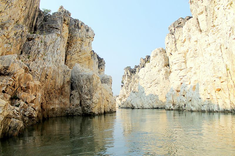
W hat to see? Several places of interest are there in Jabalpur eg Bhedaghat- Marble Rocks, Dhuadhar Falls, Satna, Khajuraho, and Panna are nearby. | ||
| JAIPUR | ||
Jaipur is the capital and the largest city of the Indian state of Rajasthan in Northern India also is called pink city | ||
| H istory: Jaipur was founded in 1727 by Maharaj Jai Singh II, who ruled Jaipur State from 1699–1744. Initially his capital was Amber, which lies at a distance of 11 km from Jaipur. After many battles with (Maratha Empire), Jai Singh was keen on the security aspect of the city. Due to this reason, he focused on his scientific and cultural interests to make a brilliant city. Being a lover of mathematics and science, Jai Singh sought advice from Vidyadhar Bhattacharya, a Brahmin scholar of Bengal, to aid him to design the city architecture. Vidyadhar referred the ancient Indian literature on astronomy, books of Ptolemy and Euclid. Jantar Mantar is a result of this interation. | |
H ow to reach? Jaipur is well connected by air, train as well road. many good Volvo buses also plies between Delhi and Jaipur | ||
W here to stay? There are many good hotels in Jaipur eg Oberoi Rajvilas, Fab Hotel, Sarovar Portico, Park Prime, Fortune Select, Grand Residency etc | ||
W hat to see? There are many places of tourist importance eg Hawamahal, Amer Palace, City Palace, Jantar Mantar Jalmahal etc | ||
| ||
H istory: The city was founded by one Raja Rawal Jaisal, a Bhatti Rajput ruler, in approximately 1156 A D. The raja choose Trikut hill as the new site for his fort as his previous fort at Luderwa (16 km from present Jaisalmer) was vulnerable towards enemy attack. The Bhatti Rajput rulers were still in line. They were the sole guardian of the city and thus mustered enough wealth through taxes levied on the passing caravans, of which there was no scarcity. For many years Jaisalmer remained out of bound from the foreign rulers because of its location & terrrain. In Thirteenth century, Ala-ud-din Khilji, the Turk-Afghan ruler of Delhi laid the siege over the city as he was upset with the Bhatti Rajput rulers as they stopped and looted one of his royal caravans. The siege lasted for around 9 years and when the fall seemed eminent the Rajput womenfolk of the city committed Jauhar (self Immolation to avoid disgrace). In the modern era, Jaisalmer was still a tough nut to crack and was the last among the Rajputana royals to sign the 'Instrument of Agreement' with the British establishment. Even that was achieved after long hours on the negotiation table and after much cajoling from the British establishment in India. In the year 1947, royals signed the agreement to remain in just independent India. Since then it has developed itself into a major tourist destination as well as a cultural hub of the western India. | ||
H ow to reach? By Air : Jaisalmer is connnected to several cities in India via several to flights Jaipur.By Train : Jaisalmer falls on the railway route between Delhi/Jaipur to Barmer thus connected to Delhi and Jaipur by train service. By Road : Jaisalmer is connected to rest of the country by NH-11 and NH-125 and is about 560 km from Jaipur and 285 km from Jodhpur. | ||
W here to stay? There are several hotels and camps where one may stay here. Some of the hotels are : Desert Spring Resort, Bhati Desert Camp, The Mama's resort and camp, Royal pavalion camp, Hotel Royal Haveli etc | ||
W hat to see? There are several things to do in Jaisalmer in addition to enjoy the desert in one of the desert camp or taking desert safari. Places to see are Jaisalmer fort, Patwon Ki Haveli, Gadsar Lake, Jain Temples. One may plan a visit to Mount Abu and Jodhpur from here. | ||
| ||
H istory: Jodhpur history revolves around the Rathore Clan. Rao Jodha, the chief of the Rathore clan, is credited with the origin of Jodhpur in India. He founded Jodhpur in 1459. The city is named after him. The Rathores enjoyed good relations with all the Mughals, except Aurangzeb. During British Raj Jodhpur was largest princely state in Rajputana. | ||
H ow to reach? By Air : Jodhpur has its own airport is is connected to various cities through domestic airlines. By road Jodhpur is connected to Jaipur, Jaisalmer, Barmer etc since it is located on NH112 & NH14. | ||
W here to stay? Hotel Garden Villa, Hotel Image Point, Hotel Cosmopolitan, Jodhour Elite, Umaid Bhawan Palace, Mihir Garh, Arch Boutique Home stay etc. | ||
W hat to see? : Meragarh Palace, Umaid Bhawan Palace, Jaswant Thada, Mandore Garden, Rao Jodha Desret Rock Park, Kailana Lake, Balsamand Lake, Chamunda Devi Temple, Rajsthani Food and clothes. | ||
| ||
Kolleru Lake is located in Andhra Pradesh 15 km from Eluru (Ellore) town in between Godavari and Krishna Delta. It is largest (bird sanctuary covers 308 km2) fresh water shallow lake in Asea. Many birds including Siberian Crane migrate to this lake and this is the main tourist attraction here. | ||
H istory: Two copper plates of the early Pallava dynasty have been found in the lake, tracing its history to Ganga Vanshi Odisha kings. According to legend, the Gajapathi fort was located at Kolleti Kota on one of the eastern islands of the lake beloged to them. The enemy general "muhammadan" probably a Bahamany general encamped at "Chiguru kota" located on the shores. In some ways, the lake protected the Odia forces. | ||
H ow to reach? Ellru is well connected by train and road and one can reach Kolleru bt road from here.The sanctuary is approachable from all four sides of the lake by road, directly to the following places. Atapaka – 2.5 km from Kaikaluru town Bhujabalapatnam - 6 km from Kaikaluru pallevada -9 km from kaikaluru town Kovvada Lanka—7 km from Kaikaluru town *Murthiraju Tanks – 8 km from Nidamarru Gudivakalanka – 3 km from Gudivakalanka or 15 km from Eluru, The nearest city by road or rail. Prathikola Lanaka or 19 km from Eluru. The nearest city is Eluru, which is 35 km by road. Kolletikota -18 km from Kaikalur. | ||
W here to stay? Accommodation: Hotels in Eluru, Kaikaluru, Akividu, Bhimavaram and Vijayawada | ||
W hat to see? Bird Sanctuary , Lake , Anjaneya Swami temple, Sai Baba Temple etc. | ||
| ||
Kodai Kanal is a hill station in Tamil Nadu at a height of 7000 ft (2133 m) above MSL. Near rail head is Kodai Road Railway Station. | ||
H istory: Original residents of Kodaikanal were the Palaiyar tribal. The earliest references to Kodaikanal and the Palani Hills are found in Tamil Sangam literature of the early era. Modern Kodaikanal was established by American Christian missionaries and British bureaucrats in 1845, as a refuge from the high temperatures and tropical diseases of the plains. In the 20th century a few elite Indians came to realise the value of this enchanting hill station and started relocating here. Tourism has become the main occupation here due to its nice weather and natural beauty. | ||
H ow to reach? By air via Madurai - the nearest airport 120 km away. Other near by airports are Tiruchirapalli and Coimbatore. Kodai Road Railway Station is the nearest rail head (between Madurai - and Chennai) but most of express trains stops at Dindigul from where too one can travel to Kodaikanal by bus or taxi. Distance from near by cities are : Chennai - 528 km, Madurai : 120 km Coimbatore: 173 km Trichy : 200 km Dindigul : 100 km. | ||
W here to stay? : Fab Hotel Tranquil heights Hotel, Hotel Sierra, Sterling Kodal Lake Hotel, Tanzanite Inn, Le Poshe by Sparse, Kodai International. Lumino Fair Stay, Jem Valley, Sivpriya, Seven Roads Grand Inn, and many more. | ||
W hat to see? : Kodai Lake, Bryant's Park, Suicidal point, Coaker's walk, Silver Cascade Falls, La Sleuth Church, Mannavur Lake, Berijam Lake, Kurinji Andavar Temple, Pine forest, Silent Valley View Point, Pillar Rocks and many more places. | ||
| ||
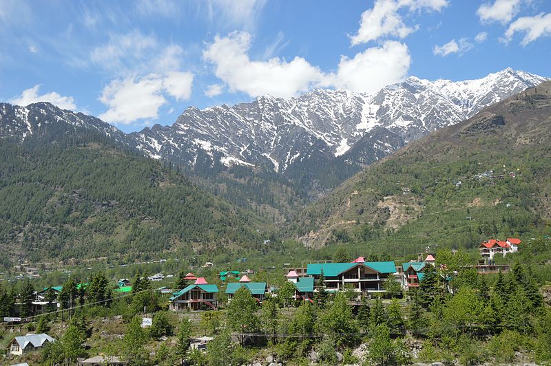
Manali is a high-altitude (2050m) Himalayan resort town in India’s northern Himachal Pradesh state. It is backpacker's & honeymooner's favourite destination. Set on the Beas River, it’s a gateway for skiing in the Solang Valley and trekking in Parvati Valley. It's also a jumping-off point for paragliding, rafting and mountaineering in the Pir Panjal mountains, it is also home to 4,000m-high Rohtang Pass.Kullu is the capital town of the Kullu district. Located on the banks of the Beas River it is about 10 kilometres north of the airport at Bhuntar. Kullu Valley is a broad open valley formed by the Beas River between Manali and Largi. | ||
H istory: Kullu was earlier known as ‘Kulanthpitha’, which translates to ‘The End Point of the Inhabitable World’. This is because Kullu was isolated from the world and not easily reached up. This has largely allowed it to retain its traditional charms and customs. It is of great historical significance and has been named in the epic tales of the Ramayana, Mahabharata and Vishnu Purana. It is believed that Kullu derives its name from ‘Kalut’, which was a tribe in the upper valley of River Beas. This is also how Kullu got its name. It is believed that Lord Manu first stepped into the earth from the celestial boat onto this land. The exact spot where he established his home is the present day Manali, which is believed to be adapted from ‘MANU-ALAYA’, which translates to “Home of Manu”. It is beieved that it ws here that the human race came into being after the deluge. The valley also played a pivotal role in trade between Central Asia and the Southern Plains and also acted as a path to Lahaul and Ladakh. . | ||
| ||
H ow to reach? :Rail: There is no close railhead available close to Manali. The nearest broad gauge railheads are at Una 250 km away, Kiratpur Sahib is 268 km , Kalka 275 km, Chandigarh 310 km and Pathankot 325 km away . The nearest narrow gauge railhead is at Joginder Nagar 175 kilometres on Kangara Valley Railway between Pathankot and Joginder Nagar. One may travel by Road from Shimla | ||
W here to stay? There are many hotels here some of which are Mahadev Cottage, Landmark, Villa Reverine, Royal Kalinga Cottage, Kalinga Grand, Solang Ski Resort etc. | ||
W hat to see? Beas river, manikaran Gurudwara, Hidimba Temple, Manu Temple, Solang Valley, Naggar Castle,Gadhan Thekchhokling Gompa Monastery,Rohtang Pass, Hot water springs etc | ||
| ||
Kochi also known as Cochin (details given elsewhere too) is a major port city in the state of Kerala in the south-west coast of India . It is part of the district of Ernakulam. ...Kochi (also known as Cochin) is a vibrant city with breathtakingly scenic in the prosperous state of Kerala, hailed as 'God's Own Country. Informally, Cochin is also referred to as the Gateway to Kerala. | ||
H istory: Kochi was an important spice trading centre on the west coast of India from the 14th century onward, and maintained a trade network with Arab merchants from the pre-Islamic era. Occupied by the Portuguese in 1503, Kochi was the first of the European colonies in colonial India. It remained the main seat of Portuguese India until 1530, when Goa was chosen instead. The city was later occupied by the Dutch and the British, with the Kingdom of Cochin becoming a princely state. Kochi ranks first in the total number of international and domestic tourist arrivals in Kerala. Cochin Jews, also called Malabar Jews, are the oldest group of Jews in India, with possible roots claimed to date to the time of King Solomon. The Cochin Jews settled in the Kingdom of Cochin in South India, now part of the state of Kerala. Kochi 's population is mix of several culture and religion. Syrian Christians arrived in Kochi early and were only Christian till the arrival of Portuguese in 16th century when Roman Catholics became a dominant Christian group. | ||
H ow to reach? Kochi is well connected to the rest of the country and world. It has its own International airport which is the first fully solar powered airport in the world. Many domestic and International flights lands in Kochi International airport (COK). Kochi is well connected via train and road. | ||
W here to stay? Many luxury, budget hotel exists in Kochi e.g. Grand Hyatt, Trident, Fab Hotel Orchid, Wyte Fort, Treebo Esha Heritage, Ima House, Puthens Capital Inn, The International Hotel, Hotel Pearl Malabar. Phil's Residency, Hakoba Hotel, Ramda Resort, Xandari Harbour Hotel etc. | ||
W hat to see? Kerala Museum, Mattancherry Palace, Maritime Museum, Poornathrayesa temple, Jew's Temple, Vypeen Island, Pavakullam Mahadev Temple, Chinese Fishing Nets, Vasco Da Gama Square, Kadammaton Church, St Anthony Shrine, Puttuvype Beach, Spice Market, Fort Kochi Beach, Indo Portuguese Museum. | ||
| ||
Kottayam is a city in the Indian state of Kerala. It is the administrative capital of Kottayam district, located in Kerala. Kottayam is approximately 146 km north of Thiruvananthapuram, Kerala's capital city. It was also known as ‘Cotym’ and ‘Cottayam’ during the British Raj.It is one of the main centres of literature and hence called Akshara Nagari or Land of Letters. Many of the first Malayalam dailies like Deepika, Malayala Manorama, Mangalam were started and are headquartered in Kottayam. | ||
H istory: From the beginning of the ninth century AD, the history of Thekkumkoor and of Kottayam are virtually indistinguishable. Kottayam then was a part of Vempolinad, an area in the Kulashekara Empire(800 – 1102 AD). By about 1100 AD, the Kingdom of Vempolinad had split into the Kingdoms of Thekkumkur and Vadakkumkur. After their separation, Thekkumkur became an independent kingdom, while Vedakkumkur became a vassal of Cochin thekkumkoor Rule (1100 AD-1753 AD) Later, the Portuguese and the Dutch established trade relations with both these kingdoms, dealing in black pepper and other spices. After the subjugation of the Dutch by Travancore in 1742, military operations of Marthanda Varma progressed against the northern neighbouring kingdoms including Thekkumkoor. Though Thekkumkoor allied with Chempakassery and Vadakkumkoor to protect the kingdom, all of them were finally annexed to Travancore. Another source states that the ruler of Thekkumkur had sided first with the Kingdom of Kayamkulam and then with the principality of Ambalapuzha against Travancore under Marthanda Varma. After the fall of Ambalapuzha, and as the ruler of Thekkumkoorr refused to come to terms with Travancore, his capital city was taken on 11 September in 1750 by Ramayyan Dalawa, the general and prime minister of Marthanda Varma and the state was annexed to Travancore in 1753. During British rule in India, Kottayam remained a part of the Princely state of Travancore. | ||
H ow to reach? | ||
W here to stay? Many hotels are located here such as Windsor Castle & Lake Resort, Orchind Residency, Excalibur, Taj Kumarakom, Icon Classic, Tamarind Chancherry etc | ||
W hat to see? : Vaikom Mahadev Temple, Vagamon, Wild life, Illikal Kallu, Ethumanoor Mahadev Temple, Vembanad Lake, Bay Island Driftwood Museum Tomb Of Saint Alphonsa, Thangal Hill etc. | ||
| ||
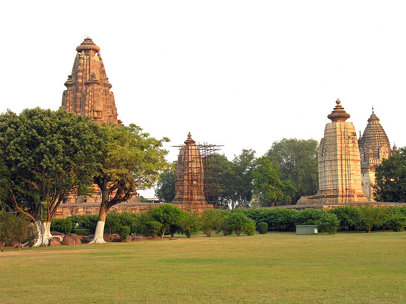
H istory: The Khajuraho temples were built during the rule of the Chandela dynasty.Their building activity started almost immediately after they came to power, throughout their kingdom to be later known as Bundelkhand. Most temples were built during the reigns of the Hindu kings Yashovarman and Dhanga. Yashovarman's legacy is best exhibited by The Lakshmana Temple. Vishvanatha temple best highlights King Dhanga's reign.The largest and currently most famous surviving temple is Kandariya Mahadeva built in the reign of King Vidyadhara. The temple inscriptions suggest many of the currently surviving temples were complete between 970 and 1030 CE, with further temples completed during the following decades. | ||
H ow to reach? Khajuraho can be reached by air, train and road. It has its own airport and there are regular flights to Delhi, Mumabi, Bhopal and Varanasi. Khajuraho has a station of its own, but very few trains halt here. However, it is directly connected with Delhi by rail. The major railhead is Mahoba, located around 63 km away from Khajuraho. Important trains from Mumbai, Delhi, Varanasi, Gwalior, Kolkata, Jabalpur and other major Indian cities halt here. Another option is to come via Satna Railway station. It is well connected by road too | ||
W here to stay? There are several hotels like Ramda Khajiraho, EuroStar Inn,Lalit Temple View, Isabel Palace, Harmovy, Radission Jass Hotel, Clarks Khajuraho, Lotus Hotel, Green Hotel etc. | ||
W hat to see? Khajuraho is famous for various monuments built by Chandela kings. The monuments are western group of temples, Chitragupta Temple, Vaman Temple, Varah Temple, Vishwanath Temple, Lalguan Mahadev Temple, Chorasi Yogini Temple, Brahma Temple, Ghatai Temple, Jain Group of Temple and the most popular Kandariya Mahadev Temple. | ||
  | ||
H istory:In 1871, the Lonavla and Khandala hill stations were discovered by Lord Elphinstone, who was the Governor of Bombay Presidency at the time.Present day Lonavla was a part of the Yadava dynasty. Later, the Mughals realized the strategic importance of the region and kept the region for an extended time. The forts in the region and the "Mavla" warriors played an important role in the history of the Maratha and Peshwa empires | ||
H ow to reach? Nearest airport is Mumbai (BOM) and Pune (PNQ). Lonawala - Khandala is on Mumbai-Pune Express way 84 km from Mumbai. Many bus running between Nunbai and Pune stops here. Lonawala is also connected by train and many trains like Deccan Express stop here. | ||
W here to stay? List of Hotels : Sai Niwas, Manas Resort, Hotel Manas, Ashoka, Hotel Ridge Heritage, Sunrise Hill Resorts, Kamath Residency, Dream Land Hotel, Mount View Resorts, Aroma Cottage, Lake View Resorts, Blissful Weekend Stay, Lonavala Tourist Tent Camping, Pawana Lake View Camping,Cherai Beach Retreat, Taraangan Farm, Krisna All Suite Stay, Upper Deck, Vintage Villa, Rhythm Lonavala, Mount Duplex Terraces, Swachh Villa, Mount Palace Bungalow,The Hill Crest Villa,Sai Bunglow and many more. | ||
W hat to see? Khandala is a hill station in the Western Ghat mountains of Maharashtra, western India. It's home to vantage spots including Sunset Point and Rajmachi Point, with views of Rajmachi Fort. Kune Falls is a 3-tiered waterfall set in a dramatic valley. Waterfalls surround the Tamhini Ghat mountain pass. East of town, the Bhaja and Karla caves are ancient, Buddhist rock-cut shrines featuring intricate carvings and pillars. Elevation: 550 m | ||
Mahabalipuram or Mamallapuram is a historic city and UNESCO World Heritage site in Tamil Nadu, India where as Kanchipuram is and important Hindu religious place. | ||
  | ||
H istory: During the reign of the Pallava dynasty, between the 3rd century CE and 7th century CE, it became an important centre of art, architecture and literature. During the rule of Mahendravarman I (600 CE – 630 CE), Mahablipuram started to flourish as a centre of art and culture. He himself was a well known poet, playwright and orator. His patronage helped the creation of a number of the city’s most iconic landmarks. This period of artistic excellence was duly continued by his son Narasimhavarman I (630 CE – 680 CE) and subsequent Pallava kings Mahabalipuram was already a thriving sea port on the Bay of Bengal before this time. A significant amount of coins and other artifacts excavated from this region also indicate a pre-existing trade relation with the Romans even before it became a part of the Pallava Empire.Ancient mariners considered Mahabalipuram as land of the Seven Pagodas. Some think that Mahabalipuram suffered from a great flood between 10,000 and 13,000 BCE. Origin of the name of the site. it also believed that place is named after benevolent King Bali, also known as Mahabali. | ||
H ow to reach? Mahabalipuram is at a distance of 58 km from and is reached by road from Chennai via East Coast Road. Kanchipuram is at 68 km from Mahabalipuram and 58 km from Chennai. Mahabalipuram and Kanchipuram cam be in covered in one circular road journey for 1 or 2 days starting and finishing at Chennai. For both places nearest airport is Chennai. There are local trains from Chennai stopping at Kanchipuram. Nearest rail head for Mahabalipuram is Chennai. | ||
W here to stay? Hotels at Kanchipuram: Welcome Hotel Kence Palm, Regency Kanchipuram, Heritage Inn, Pine Tree, Jaybala International, Hudson resorts etc, at Mahabalipuram : Radisson Blue, Taj Fissherman's Clove, Mamalia Beach Resorts, Chariot Beach Resorts, Intercontinental, Rajalaxmi GH, Mamalla Heritage etc. | ||
W hat to see? At Mahabalipuram : Shore Temple, Pancha Rathas, Descent of Ganges murals, Bheem's ball, Draupdi's Chulha etc. at Kanchipuram : Kailasnarthar Temple, Ekambareswarar Temple, Ulagalanda Perumal Temple, Kamakshi Amman Temple and several temples. | ||
 | ||
Kanyakumari is a coastal town in the state of Tamil Nadu on India's southern tip. At the junction of Bay of Bengal and Arabian Sea, the town was known as Cape Comorin during British rule and is popular for watching sunrise and sunset over the ocean. It's also a noted pilgrimage site thanks to its Kanyakumari Temple, Vivekanand rock is also located here. | ||
H istory: Kanyakumari District consists of those parts known locally as Nanjil Nadu and Idai Nadu. he Kalkulam and Vilavancode taluks were under the rule of the Chera Dynasty. When the power of Chola declined due to the rise of Hoysalas and western Chalukyas, the Venad (Travancore) Chieftains (descendants of the central Chera family) took advantage of the situation and gradually established their hold on considerable areas in Nanjilnadu. Veera Kerala Varma, one such chieftain, styled himself as "Nanjil Kuravan". The annexation commenced by Veera Kerala Varma was to a large extent continued by his successors and completed by AD 1115. | ||
H ow to reach? The nearest airport to reach Kanyakuamri is the Trivandrum international airport and the domestic Tuticorin airport. Both of these airports are located at a distance of around 82 km and 89 km from Kanyakumari Kanyakumari is connected by train and railway station is a railway terminus of the Indian Railways serving the coastal city of Kanyakumari. By road Kanyakumari is connected by NH66/ SH179 to Trivendrum and the distance is 101 km. Tirunelveli is at 85 km via NH44. | ||
W here to stay? There are many hotels in Kanyakumari such as : Hotel Sea View, Ocean Heritage, VLS Holiday home, Pioneer Grand Palace, Hotel Sea Face, Sparsa Resort Kanyakumari, Hotel Sea face | ||
W hat to see? : Kanyakumari Beach, Vivekanand Rock, Thiruvallvur Statue, Gandhi Mandapam, Kanyakumari Temple, Arulmigu Bhagavathy Amman temple. Sunset and Sunrise. | ||
Leh, is a high altitude desert city in the Himalayas, is the capital of the Ladakh region in northern India’s Jammu and Kashmir state. Originally a stop over for trading caravans, Leh is now known for its Buddhist sites and nearby trekking areas. Massive 17th-century Leh Palace, modeled on the Dalai Lama’s former home (Tibet’s Potala Palace) is a big attraction. | ||
  | ||
H istory: The first glimpse of political history is found in the kharosthi inscription of "Uvima Kavthisa" discovered near the K'a-la-rtse (Khalatse) bridge on the Indus, showing that in around the 1st century, Ladakh was a part of the Kushan Empire. A few other short Brahmi and Kharosthi inscriptions have been found in Ladakh. About 950 CE, after the collapse of the early Tibetan Empire the border regions became independent kingdoms under independent rulers, most of whom came from branches of the Tibetan royal family.. | ||
H ow to reach? Jammu Tawi is the closest railhead, located at a distance of approximately 708 Km from Ladakh. In order to reach Ladakh, you have to hire a taxi or can board a bus from outside the railway station. It will take around 15 hours to reach the heart of the city. One may also travel from Manali to Leh by road via Rohtang pass. Permits may be required. Kushok Bakula Rimpochee Airport Leh (IXL) has one the highest airport in the world at 10682 ft above MSL and there are regular flights from Delhi. It may be good idea to undertake a road trip in rented SUV from Chandigarh and cover Shimala, Manali, Leh and Khardung la Pass. | ||
W here to stay? Several hotel are there in Leh such as Yangphel GH, Hotel The Ladakh, Hotel Asia, Nubra Ecolodge, The Silk route Ladakh, Niri, La Ladakh, Royal Ladakh etc. | ||
W hat to see? Khardungla Pass- Nubra Valley, Leh Palace, Thikse Monastery, Shanti Stupa, Spituk Monastery, Magnetic hills, Sindhu ghat, Stok Palace Museum are few places worth visit. For the adventurous ones there are Enfield Bike rentals available at Manali for Manali -Leh trip. | ||
| ||
H istory: The history of Lucknow can be traced back to the ancient times of the Suryavanshi Dynasty. It is said that Lakshmana, who was the brother of Lord Rama, laid the foundation of the ancient city. This was near the Gomti River on an elevated piece of land. It was then called Lakshmanpur. It was during the year 1720 when the great Mughal emperors began to appoint Nawabs in order to ensure smooth administration in the province. In the year 1732, Mohammad Amir Saadat Khan was appointed as the viceroyal of Awadh, in which Lucknow was a major province. It was then that the powerful dynasty of the Nawabs, which changed the history of this unknown place. Under the rule of the Nawabs, Lucknow flourished like never before. After 1755, Lucknow grew by leaps and bounds under the rule of the fourth Nawab Asaf-ud-Daula. Lucknow flourished in each and every aspect, which includes poetry, dance, music and the other finer aspects of the lifestyle of Lucknow. | ||
H ow to reach? Chodhury Charan Singh Airport of Lucknow is well connected with different cities in India by regular flights. By train Lucknow has two Raiway station namely Lucknow (Char Bagh) and Lucknow Jn. Lucknow is on Northern railway and is well connected to various cities. You may also travel by train via Kanpur which is well connected to Lucknow by road. Lucknow is also connected to Agra by a new Agra- Lucknow Express way. | ||
W here to stay? Hotels : Skyotel, FabHotel Prime near Airport, Fab Hotel Hajratgunj, Fab Hotel CharBagh, The Maple Leaf, Grand Almada, Lineage, Levana. Mera Mann, Fairfield By Marriott Lucknow, Hotel , Renaissance Lucknow, Novotel Lucknow, Gomati Nagar, Hotel India Awadh, Hyatt Regency. etc | ||
W hat to see? Charbagh Station, Bara Imambara, Chota Imambara, Rumi Darwaja, Hajrat Gunj, Ambedkar Park, Sikandar Park, Planetorium, 1857 memorial museum, Bhulbhulaiya etc. | ||