TATA-JAMSHEDPUR
This is the place where the foundation of Indian Steel Industry was laid in the end of the last
century. Late Jamshedji was the founder of this city who founded Tata Iron and Steel Company at this site. This
city is named after the founder and has two names Jamshedpur & Tatanagar. It is heavily industrialized
but very clean and modern.
CLIMATE
Tropical Max 46.7deg C, Min 6.1 deg C. Elevation AMSL, 146 m / 478 ft
TRANSPORT
AND COMMUNICATION:
Rail : Tatanagar (Jamshedpur) is an important
railway junction station on the South Eastern Railway and
is connected directly to all the major cities of India,
viz. Calcutta, Bombay, Patna, Ranchi, Puri etc.
Fare (approx): Calcutta - Tatanagar Rs.328 (AC-2A), 236
(I), 94 (II). Road : Jamshedpur is connected by road with
most of the major cities in India. Regular bus services
are available from Jamshedpur to Ranchi 131 kms, Patna,
Gaya, Calcutta 252 kms, Hazaribagh etc. Internal
Transport : Mini Buses, Taxies, Auto Rickshaws and Cycle
Ricksaws are available in all parts of the town.
PLACES
OF INTEREST & EXCURSIONS:
Jubilee Park :
This is 200 Acre Park with a mini golf course and a lake.
Dimna Lake : 8 miles from
Jamshedpur nestling at the foot of Dalma hills.
Rivers Meet : The confluence
of rivers Kharkai and Suberurekha is located.
Dalma Hills : North of
Subarurenkha river it stretches from east to west by
about 16 kms. It is accessible by Jeepable road.
Aditypur: An Industrial colony
& Technical institute to train Engineers.
Jaduquora : Located
on Hata-Musabani road and is about 40 kms from
Jamshedpur.
Musabaniu : 40 kms from
Jamshedpur, Copper Mines are located.
Noamundi : 64 kms South West of
Chaibasa. It is mining centre for Iron ores.
Ghatshila : 23 miles east of Jamshedpur, Ghatshila
is the birth-place of late Bibhuti Bhushan Bandyapadhaya,
a famous writer. Timber and copper industries are situated here.
 
Go
To Top
HAZARIBAGH:
Hazaribagh, meaning hazar bagh or
a thousand gardens. Situated at 2019 fts above sea level,
this place is famous for the Hazaribagh National Park.
CLIMATE:
Tropical Max 46 deg C, Min 7.deg C. Average elevation: 421 m./ 1380 ft AMSL
TRANSPORT
AND COMMUNICATION:
Lying 93 km from Ranchi and 233 km from Patna,
this city is well connected via road to Ranchi &
Patna. The nearest Airport is at Ranchi and nearest
railway station is at Hazaribagh Road 63 Kms from the
city.
PLACES
OF INTEREST & EXCURSIONS:
Canaray Hill: The Hill is situated just out
the town, & serves as a observation tower. From here
one can
have a
panoramic view .
Hazaribagh National
Park
: Stretching over 184 kms,
this national park is home to lots of different species.
Nestled in low hilly terrain the wild life enthusiast
love to visit the park. It
is one
of the reserves that falls under the Project
Tiger category. Ten watch towers and ground
level hideouts have been constructed for viewing tigers,
panthers, deer, sambar, nilgai, chital, elephants,
chinkara and mouse deer, and are specially
recommended for professional photographers as well as for
viewing these animals in their natural habitat.
Hazaribagh Lake: Lying just
outside of the park this lake adds to the attractions to
the visitor
Tilaiya Dam:
This dam, situated across Barakar River is a preferred
attraction for the tourists. It is 55 kms away from
Hazaribagh. The main road from Barhi, on G.T Road (NH-2) passes
through the reservoir and the hillock offers a
breath-taking sight.
Urwan Tourist Complex: Few
kilometers from the Tilaiya Dam, is Bihar State Tourism
Development Corporation's Tourist Complex at 'Urwan',
where one can consider spending time by the side of the
dam and can enjoy boating and other water sports.
Interested tourists can follow the main road and drive to
Hari Har Dham at Bagodar, which is famous for the 52 feet
high Shiv Ling that took 30 years to complete and is
believed to be the tallest in the world.
Konar Dam: There
is another Dam - Konar dam - which is 51 kms from
Hazaribagh
 
">
Go
To Top
DHANBAD
This
city lying 167 kms from Ranchi,
it is a
higly industrial and commercial town in Chotanagar
Plateau and has the distinction of lying in the
heart of India's richest coal-feilds at Jharia.
CLIMATE:
Tropical
Max 44 deg C, Min 8 deg C. Elevation AMSL: 258 m / 847 ft
TRANSPORT
AND COMMUNICATION:
This town is well connected via
road to all the major cities in the state. It has small
airstrip, with the nearest airport at Ranchi.
Dhanbad
has an important railway station on Eastern Railway
and is very well connected with Patna, Calcutta, Delhi and
other important Cities in India.Fare (approx):
Calcutta-Dhanbad Rs.328 (AC-2A), Rs.236 (I), Rs.100
(II).
PLACES
OF INTEREST & EXCURSIONS:
The Collieries, various technical
institutions and research center of high order,
attractive neighborhood and the landscape are the
attractions of this industrial city.
Topchanchi Lake: T he
Topchanchi lake lies 37 kms from Dhanbad and is almost on
N.H.2. It is an artificial lake surrounded by green hills
and forests and a wonderful place for picnic and spending
quiet holidays.
Jharia:
A suburb of Dhanbad is a rich colliery center and has
extensive commerce.
Sindri - 30kms - Fertilizer and
other factories and Bihar Institute of Technology is
here.
Maithon Dam: It
is 52 kms from Dhanbad. Maithon can also be translated as
'Mother's Abode'. Maithon has the biggest reservoir in
Damodar Valley Corporation. This dam, designed for flood
control, has been built on Barakar river. It has a unique
underground power station which is first of its kind in
S.E. Asia. just a little away from the dam lies an
ancient temple at Kalyaneshwari.
The lake at maithon is spread over an area of 65 sq.kms.
On an island in the lake is a rest house which offers
accommodation. Boating and fishing facilities are
available. Close by, a deer park and a bird sanctuary
have been established.
Panchet Dam: It is
constructed on Damodar river, is 22,155 ft. long and 134
ft. high. A hydel station has also been constructed
against the back ground of Panchet Hill in the eastern
side of dam.
 
Go
To Top
BOKARO:
Lying
along the Damodar River, just west of one of India's
largest iron and steel plants, along the Dhanbad-Ranchi
highway is India’s biggest steel city complex. The Plant
was conceived as the country’s first Swadeshi Steel
Plant to be built with maximum indigenisation going into
the equipments, materials and know-how. Thus, this
project has been a radical shift from the earlier
dependence on foreign sources for know-how and
consultancy, design and equipment, supervision, erection,
etc. to almost a full measure of self-reliance and
confidence.Situated in the Chhotanagpur Plateau, the vast
rolling topography of the city is typical, strewn by
graded valleys and winding streams. In this setting,
within a short period of two decades, a new city with a
strong multi-dimensional economic base, has blossomed
into a regional urban centre of around 8.0 lakh people
drawn from different parts of the country, giving the
city the character of Mini India.
CLIMATE:
Tropical 46.7 deg C Min: 6.1 deg C, Elevation AMSL: 218 m / 715 ft
TRANSPORT
AND COMMUNICATION:
Air:
There is no direct air connection. It has a small airport usually for use for VIP's and SAIL planes. The nearest commercial airport is in Ranchi. Rail: Bokaro is
near Dhanbad, which is on the main Delhi-Howrah railway
line. Bokaro lies on Muri-Chndrapura Sector of SE Railway.Road: it is well connected with
all the major cities by good motorable roads.
PLACES
OF INTEREST & EXCURSIONS:
Bokaro
Steel City: As the fourth
integrated steel plant in the Public Sector, bokaro steel
city was conceived in 1959. Bokaro Steel Plant actually
started taking shape in 1965 with the collaboration of
the then United Sovereign Of Soviet Republic. Major
coalfields are located nearby. Bokaro City was built to
provide housing and other community facilities for the
plant's employees.
Garga Dam And Parasnath Hills:
Bokaro City is located in picturesque
surroundings on the southern bank of river Damodar with
Garga, one of its tributaries meandering along the
southern and eastern outskirts of the city. On the north,
the city is flanked by the high ranges of the Parasnath
Hills and on the south just beyond the river Garga, it is
enveloped by the Satanpur hillocks.
Bokaro Ispat Pustakalaya:
It has a collection of over 40,000 books that
meets the reading requirements of the people in the
township.
City Park: Bokaro has a
well-maintained City Park with an artificial lake.
Recently three artificial islands have also been created.
Jawaharlal Nehru Biological Park:
A Biological Park named after Jawaharlal Nehru with a
variety of animals and birds and a modern aquarium is
another attraction.
 
Go
To Top
Nehtarhat
:
The Queen of Chhotanagpur The popular hill station,
Netarhat, which is 156 kms from Ranchi is known as the
Queen of Chotanagpur. Situated at a height of 3,700 ft.
above sea level, Netarhat is a beautiful resort, during
summer. Dense forests, serpentine roads, cool bracing
breeze, moonlit nights all add to the beauty of the
magnificent place. This place is an out of this world
experience.
CLIMATE:
Sub Tropical 38 deg C
Min: 1 deg, Elevation: 1,071 m/ 3513 ft C
TRANSPORT
AND COMMUNICATION:
Air:
The nearest airport is Ranchi. Rail:The
nearest railway is at Ranchi, on South East Railway.Road:
There are daily bus services from Ranchi to
Netarhat
PLACES
OF INTEREST & EXCURSIONS:
Sunrise and Sunset Views:The
sunrise and sunset views are very fascinating here. The
tourist bungalows here (Hotel Prabhat Vihar of BSTDC and
Palamu Bungalow) are an ideal place for viewing the
astounding sunrise. 10 kms from here, 'Magnolia Point' is
famous for its stunning sunset view.
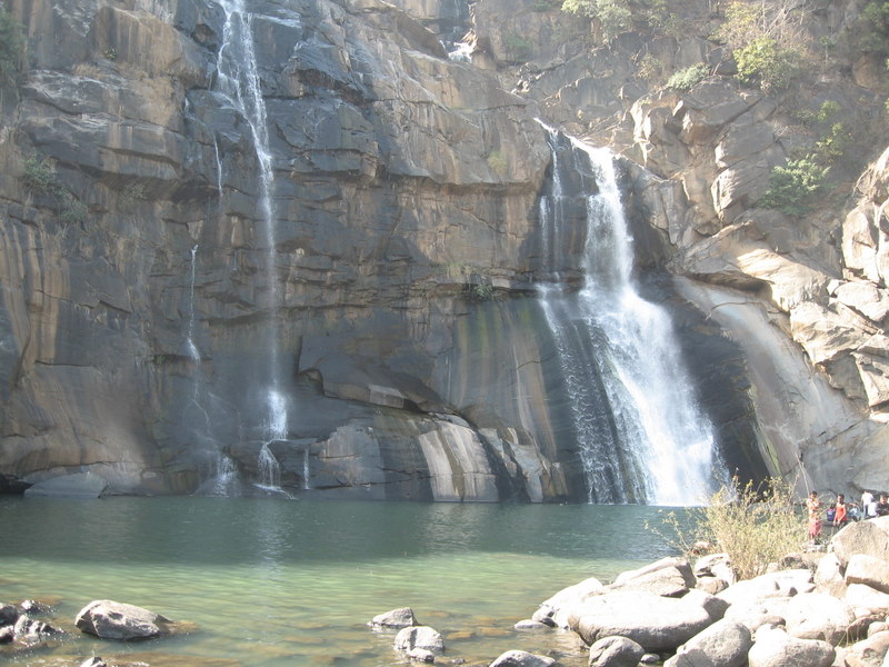
Upper Ghagri Water Falls: 6 kms
from Netarhat , these cascading waterfalls make up for a
unique picnic spot.
Lower Ghagri Water Falls: Situated
at a distance of 10 kms from Netarhat, in lush green
forest, lower Ghagri waterfalls is a place of scenic
beauty and a popular picnic spot.
Koel ViewPoint: This place is 3
kms from Netarhat and a good site for viewing Koel River.
View Tower: View
Tower is situated near Forest Bungalow, from where scenic
beauty of Netarhat can be seen.
Lodh Falls: Located 61 kms from
Netarhat, it is one of the biggest water falls of Bihar,
where water falls from a height of 468 ft.
Sadni Falls:35
kms from Netarhat, it is a snake type water fall and is
very popular picnic spot.

Go
To Top
DALTONGANJ
(Betla National Park)
:
The town is located in
the Palamau region of Bihar around 150 kms from Ranchi.
There are many places of tourist interest near this town.
The Betla national park is one of them.
Betla is famous for its Sal trees. The National park is a
trek for the tourists because of its high altitude and
also deep and dense forest abounding it. The right time
to visit this region is between October and March.
CLIMATE:
Tropical 47 deg C
Min: 7 deg, Average elevation: 226 m/741 ft C
TRANSPORT
AND COMMUNICATION:
Air: Nearest airport Ranchi is
161 kms away from Daltonganj (Betla) Rail:
Daltonganj is well connected to varous cities by
Railways. And the other nearest railway station is
Ranchi 161 kms from Betla. Road: Good
motorable road connects Daltonganj to nearby cities.
PLACES
OF INTEREST & EXCURSIONS:;
Betla
National Park (
Palamau
Tiger Reserve): The reserve is 25 kms for
Daltonganj, 150 kms for Ranchi, spreading over aprrox
1026 sq kms.Large herds of Gaur and Chital are commonly
seen. Elephants are present mostly after the monsoons up
to the time when water holes begin to dry up in March.
Tiger, Panther, Sloth Bear, Wild Bear, Sambhar, Nilgai,
Kakar, Mouse Deer are also permanent residents. Large
families of langurs are an ever present attraction.
Palamu is now one of the nine Tiger Reserves in India
under Project Tiger. It has waterfalls and hot springs
too. Once the seat of Chero kings,it has many historical
monuments and a fort of 16th century inside the forest.
The other rivers which drain Palamau are Koel and
Burha which eventually empties into the famous Sone
river.
There are no regular tour but trip to
sanctuary by jeep can be arranged, from the Director
Tiger Project (Jail Compound) Daltonganj, Palamau, Tel:
350. Charges for jeep is Rs.10 per km. and entry fee
Rs.100 (Capacity 6-8 person).Spotlights & guide are
provided with the jeep. Charges for spotlight is Rs.25.
Timings :- 0500 to 1900 hours.
Entry fees for vehicles to National Park
Station Wagon - Rs.75 for 15 persons.
Car and Jeep - Rs.60 for 6 persons.
Bus - Rs.160 for 40 persons.
Facilities: There are 3 elephants of the Department of
Tourism and one jeep of the ForestDepartment to take the
tourists around the park with guide and spotlight. Five
Watch Towers from where animals can be observed and
photographs taken.

Go
To Top
Mc CLUSKIEGANJE:
Mc Caluskieganje, 60 kms from Ranchi on Highway 41 is a
sleepy hamlet amidst green forests. The name evokes
nostalgia and one gradually discovers that the place was
once popular with Angle-Indian community. During the
1950s there were no less than 100 Anglo-Indian families
with their typical cottages, clubs and shops. It is also
know for it's haunted Bungalows, formerly inhabited by
it's Anglo-Indian Community.
Climate: This little township has a sparkling weather with warm days and cool evenings. Average elevation: 450 m/ 1476 ft

Go
To Top
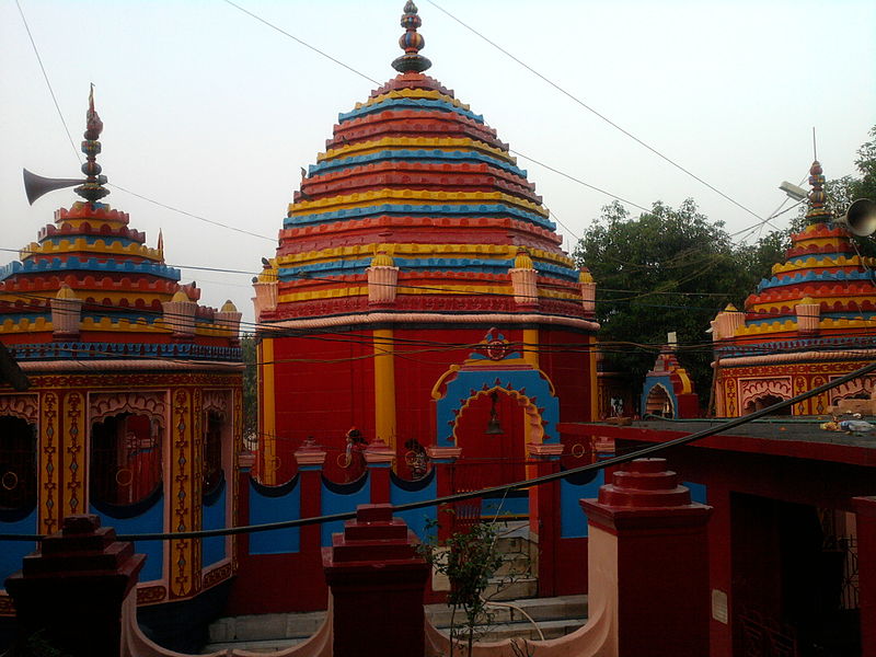
RAJARPPA
Rajarppa, 80kms from
Ranchi situtated on the confluence of Rivers Damodar and
Bhairavi, popularly known as Bhera. Many pilgrims come
here to visit the temple of Maa Chhinamastika and and it
has grown into a famous pilgrim spot for Hindu devotees,
mainly from Bihar and West Bengal. On Makar Sakranti
(January 14), a religious fair is held, which many visit.
On Dussehra, the number of visitors increases
considerably
Climate : Tropical climate. Elevation: 346 metres (1,135 ft)
Go
To Top
|